Wednesday 30 June 2010

Hotel Cannon D'oro, Cocconato
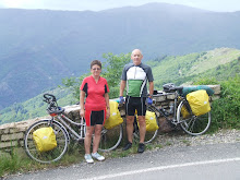
Had a good breakfast. We were well looked after. Large blocks of fresh cheese, fresh fruit, a ham to slice meat off and whole pineapple. Yoghurt and cake. We were given a very nice bottle of red wine to take with us, I think for our effort in reaching the hotel. How could we refuse, but had to carry it all day. Decided to take busier roads today as they are straighter without any hills. The smaller ones meander too much and are taking too long in the heat. 34c at 18.30 today!
Hotel Cannon D'oro, Cocconato
Found hotel last night after an unexpected push uphill. Exhausted but what a find! Great views of surrounding hills with an inner courtyard and several dining terraces. Very peaceful with only us staying there.

Tuesday 29 June 2010

Cisterna d'Asti
A long push to the top. Still very hot and found a seat in the shade where we ate lunch and refilled our water bottles. A regular occurence as the heat is unrelenting. Everywhere is closed, so after resting continue downhill towards Ferrere looking for accommodation. Camping is not worth thinking about because of the heat. Also there are no campsites inland to be found. Quite tired now but the only sign we have seen for a hotel is 8km away at Cocconato. We go in search of it.
Road up to Cisterna
Stayed in hotel 'Rame' last night. Large apartment with 3 course dinner and wine on the restaurant terrace. No English spoken so we got by with some French. Really nice meal.
30 plus degrees today. Route fairly flat passing through Sommariva, Ceresole, Monteu and Canale until we took the wrong road and had to go up and over the road into Cisterna as it would be a long way back.

Monday 28 June 2010

Fossano
Left campsite very early as we had no provisions. Had pizza bread encrusted with salt from local bakery. Very humid now so the salt was needed. Continued on, filling our water bottles several times. Found another shop and had late breakfast. Bread, meat, bananas and yoghurt. A cyclists staple diet.
Later stopped in Fossano, which is rich in medieval, renaissance and baroque buildings. It is characterized by the ancient portici (arcades), built on both sides of via Roma (the main street of the old town) and also along other streets. Had more pizza, coffee and ice-cream. Catching up on replacing energy from the previous day.

Sunday 27 June 2010

Italy
Long descent down from top, 11 miles. Lots of bends, a bit like the 'Italian Job'! Stopped at hotel in Argentera for lunch. Although it was late afternoon and we were famished. We spoke no Italian and they spoke no English, a bit outside our comfort zone, we asked for pasta. They fetched the cook who appeared with a fist full of uncooked pasta, which we nodded to. We had a very enjoyable lunch. Spaghetti Bolognaise followed by apple cake and coffee. Full up, we continued on our way looking for a campsite. We wouldn't reach the bottom until the next day.
Col de Larche
At the top of Col de Larche we stopped to eat bread, cheese and pate before descending. Border into Italy was marked by two huts, more like sheds. One selling cheese and the other selling wine!

Col de Larche
View of snow on the top of the Col de Larche and cyclist climbing up on the road behind us. Managed to cycle all the way to the top without pushing, having only muesli and coffee for breakfast and a banana on the way up, although we stopped many times near the top for water.
Route to Col de Larche
Carol en route to Col de Larche. Steady climb uphill with lots of views. Stopped many times for 'photos and video. Lots of motorcycles as it is now Sunday and a pleasant day for a ride out!

Saturday 26 June 2010


River along route to Jausiers
Staying on campsite at Jausiers at foot of the climb which will will commence tomorrow. Raining in evening, again, with thunder and lightening.
Mountain road to Barcelonette and Italy
Road follows river uphill along the valley which is very scenic with little traffic.
We are now going to cross into Italy on the D900 over the Col de Larche 6,550 feet (Italian, Colle della Maddalena). Although this is a bit higher than crossing the Col de Mongenevre 6,100 feet, it is less busy. We will enter Italy further south than planned near Cuneo and head NE towards Verona.

Friday 25 June 2010

St. Vincent-les-Forts
Steep road to village. Nearly there or so we thought. Road continued to twist and turn and was nearly 6.30 p.m. before we reached the top. Now beginning to rain heavily so decide to stay at a B&B. Magnificent views of the lake from the terrace. Only 3 of us staying there but no chef. The owner cooks us a large meal. Now thunder & lightening so good choice of accommodation. Shower & comfy bed, heaven! Beginning to wonder what we are letting ourselves in for!
Lac de Serre-Poncon
Scenic route met D900 at lake. This is one of the largest artificial lakes in western Europe. The lake is formed by the waters of the Durance and the Ubaye rivers, flowing down through the Hautes-Alpes and the Alpes du Sud to the Rhône River. The lake is dammed by the Barrage de Serre-Ponçon, a 403 feet high earth core dam.
Climbing uphill again, black arrows, through a short tunnel, stopping to rest frequently as it is very hard work. Still heading for campsite at St. Vincent-les-Fonts. A village on top of the mountain 3,280 feet up.
En-route to St. Vincent-les-Forts
Sign of things to come. No turning back now!
En-route to St. Vincent-les-Forts
Very hot day. Stopped for picnic lunch and take in the views.
En-route to St. Vincent-les-Forts
Stopping for more photo's. Followed river deeper into the mountains for most of the day. More wooded mountains appearing with every turn of the road.
En-route to St. Vincent-les-Forts
Took scenic route D951 from campsite at Sisteron. Going deeper into the mountains now. A forested valley coming down to meet the road, with lots of peaks. Very remote, going up river, climbing to 3,280 feet for the second time today.

Thursday 24 June 2010

Sisteron (awaiting the Tour de France)
The fortified citadel which crowns the city and overlooks the Durance river is a complex of diverse architectural periods including the 12th 14th 16th 17th, and 19th centuries. Inside the walls is the Notre Dame du Chateau Chapel and two museums. From the terrace of the Citadel there is an excellent view of the old city below onto the timeworn tile roofs of the houses lining the river banks. This ancient part is quite interesting with its tiny squares planted with trees and fountains gushing here and there throughout the winding streets.

Tuesday 22 June 2010

Dignes-les-Bains
Digne is a major town, with residential areas and shopping centers, it has a compact center and a beautiful setting, next to the fast-flowing Bléone river and with forested mountains all around. The long main street through town is completely shaded by the overhanging branches of the plane trees. Digne is the center of one of the principle lavender regions of Provence, the Pays de Digne.

Dignes-les-Bains
Dignes was a strategic site between Provence and the Alps and occupied throughout Antiquity. In the early 19th century Digne was a luncheon stop for Napoléon. Today it's a popular tourist stop, with only one of its attractions being the thermal baths that justify the -les-Bains part of its name.
It has 8 hot springs (and one cold), flowing from the St Pancarace cliffs. The water, starting at 42°C (107°F), contain sulfur, calcic (lime and calcium), strong minerals and are lightly radioactive.
First view of snow topped mountains from Dignes-les-Bains
Headed north from canyon, about 12 miles uphill from campsite, towards Dignes-les-Bains (a major town) in search of replacement tent poles. Mountains on both sides as we went down into the valley, a steep descent with z bends, very scenic. Stopped at Estoublon for lunch at a cafe with grapevines overhead shading us from the sun. Worth the stop! Continued on undulating road up river to Mezel, stopping to take photo's.
Found sports shop and tent poles. Tent looks a bit more normal now!

Monday 21 June 2010

Canyon du Verdon
View from Col d'illoire across canyon. Thin line half way down is the main road. A full loop around the canyon is just over 62 miles, including the Route des Crêtes, and takes a very full day.
Col d'illoire
Twisty roads leading from the Lac de Sainte Croix to the Col d'illoire, 3,172 feet. We cycled from the campsite at Moustiers-Ste-Marie, leaving all our luggage behind, and cycled off for the day to the Col d'illoire. Very good views of Lac and mountains behind the plateau towards Riez and the bottom of the canyon. Returned to campsite to find more broken tent poles and A shaped tent! Moved broken rods to the end and shortened them. Better shape now. Need to find camping shop for replacements.
Canyon du Verdon is a spectacular canyon that forms a border between the Alpes-de-Haute-Provence and the Var. Up to 2,296 feet deep, the 13 mile long canyon varies in width between 19 and 328 feet at the bottom and 650 to 4,900 feet at its rim. The canyon was formed in the Quaternary Era, as a result of earth movements while the Alps were "growing" upwards and from erosion of the Jurassic limestone by the Verdon river. They remained unexplored until the 20th century.
Lac de Sainte Croix flowing from the Gorge de Verdon. The lake is about 6 miles long and 1 mile wide at the widest part. Although the village of Ste-Croix-de-Verdon gave the lake its name, the village of Les Salles-sur-Verdon on the opposite side is more a part of the lake itself. When the dam was built the old village was flooded and now rests 130 feet below the surface of the water. Les Salles-sur-Verdon moved to higher ground, taking some of the old village with it, including the church belltower and the fountain.
Mousiers-Ste-Marie
View of rooftops and the 12th-century Notre-Dame church which was restored in 1928. It's topped by a four-level Lombard Romanesque (Italianate) bell tower, carved from golden-brown tuff.
Moustiers-Ste-Marie
The Notre-Dame de Beauvoir chapel dates back to the time of Charlemagne in the 8th century, and was restored in the 12th and 16th centuries and is built on the site of one from the 5th century. The steep walk up to the chapel follows a wide paved path passing through defensive doorways. The path, lined with 12 stations of the cross, has been used for pilgrimages to the chapel since the year 470. There are fantastic views of the village to the expanse of the Maire valley, the far hills and the Lac de Ste Croix.
Moustiers-Ste-Marie
The village sits astride a rushing mountain stream that divides the two halves with a narrow rocky canyon, below a narrow notch at the base of rocky limestone cliffs. It has narrow medieval streets and vaulted passages. Above the village is the Notre-Dame de Beauvoir chapel sitting high in the notch, behind the ruins of the ancient defensive walls. Above the town, a star hangs on a 738 feet long chain suspended between two cliffs. According to legend, during the crusades a knight of Blacas held prisoner by the Saracens vowed to hang a star over the village on his return. The star has never been replaced but the chains have. Camped at base of village for two nights.

Sunday 20 June 2010

Valensole
Left campsite towards Puimoisson amid dark skies across a flat open plain, with fields of lavendar beginnning to flower and thunder and lightening over the alps in the distance. Wondered whether to change direction and go north missing out the Canyon du Verdon but continued as the weather appeared to be moving away from us.

Saturday 19 June 2010

Valensole - First view of the Alps
Cycled up long meandering hill to 'Col de la Mort d'Imbert' 1938ft, then downhill into Manosque, a large town with narrow streets with a Moroccan feel to it, in search of replacement tent poles. A few have begun to snap and the rounded tent is beginning to look a bit misshapen! No luck. Continued to Valensole to a municipal campsite on top of a hill. Very windy and exposed blowing straight through the shower block which had pull chains. A bit cold.

Thursday 17 June 2010

Le Boisset camping a la ferme. Quiet campsite with cherry orchards. All the campers were in one field and the elderly french lady let us camp in the field on the other side of her farmhouse. Perhaps it was because she thought my french was good or we needed some peace and quiet for a rest! We had it to ourselves with views across the valley to Viens. We sat in the field eating dinner in the sunshine with freshly picked cherries from the farm. First evening we could sit outside without any rain.
Luberon The Luberon is a forest that borders the southern Vaucluse, a large natural park with castles and medieval towns. There is a 146 mile cycle route around the massif and the Parc Naturel Régional du Luberon, marked in both directions. It follows narrow lanes through picturesque villages, avoiding busy roads, which are placed mostly on top of hills, so it climbs at times giving good views along the valley. We followed it for the day going east through Oppede-le-Vieux, Menerbes, Bonnieux, Apt and stopping at Le Boisset to camp. The path in the photo is on an old railway track.

Tuesday 15 June 2010

Maubec, situated at the foot of the Luberon mountain, has narrow streets and a baroque church.
Decided to stay another day to dry everything out. Met an Australian couple touring who gave us some bread and milk which we had with tinned pate for breakfast before walking to the village shop in flip flops, as our shoes were soaked. The couple later moved into a gite as their tent had leaked and we joined them for a cup of tea and cooked our dinner on their stove..
Maubec a small village in Luberon, Vaucluse, Provence
Left Avignon in pouring rain, which had fallen all night, after sheltering for a while and having coffee and half a long roll and jam for breakfast. Cycled all day in the rain and eventually found a campsite in Maubec where a Dutchman kindly made us coffee whilst we put up our tent in the rain. Decided to go to bed at 9.30p.m. with no dinner as it was now thundering and lightening. The campsite was awash with water and there was no hope of reaching the shops. Continued raining heavily all night.

Monday 14 June 2010

Pont Saint-Bénezet also known as Pont d'Avignon
The bridge originally spanned the Rhone between Avignon and Villeneuve-lès-Avignon on the left bank. It was built between 1171 and 1185, and originally spanned 2,950 feet, but it had frequent collapses during floods and had to be reconstructed several times. Over the centuries its collapsed arches were replaced by rickety wooden sections. In 1668 after a catastrophic flood it was no longer repaired. Now only 4 of the original 22 arches remain.
Avignon, Palais des Papes
Several popes and antipopes lived here from the early 14th to early 15th centuries.

Arrived in France at 6.30a.m. and cycled from Orange to Jonquieres campsite, where we left off last year, along peaceful lanes with vineyards and the smell of perfume in the air. It was good to be back! Continued to Avignon the next day and stayed overnight after touring the city during the afternoon and having dinner in the main square.

Saturday 12 June 2010

Orange to Norfolk 2010.
Leaving Lakeside on the European Bike Express to Orange. Cycle tour covering the Luberon, Gorges du Verdon, over the Alps via Col de Larche 1996m, to Cuneo, Italy. Going North-east visiting Lake Garda, Verona, then north along the route Via Claudia Augustus, the Romans only imperial road across the Alps. Over the Reschenpass 1504m which goes over the main chain of the Alps and the Fernpass 1212m in the Tyrolean Alps. Continuing north-west towards Fussen then north through Germany to the Main and link up to the Rhine to Holland.